
1.2 Continental Margins
Portions modified from "Physical Geology" by Steven Earle*
Continental margins refer to the region of transition from the land to the deep seafloor, i.e. between continental and oceanic crust. In an active continental margin, the boundary between the continent and the ocean is also a tectonic plate boundary, so there is a lot of geological activity around the margin. The west coast of the United States is an example of an active margin, where the coastline corresponds with the boundary between the Pacific and North America Plates. A passive continental margin occurs where the transition from land to sea is not associated with a plate boundary. The east coast of the United States is a good example; the plate boundary is located along the mid Atlantic ridge, far from the coast. Passive margins are less geologically active. Figure 1.2.1 shows an idealized passive margin. When examining this figure, and others like it, note that there is significant vertical exaggeration; the depth scale covers approximately 5000 m, while the horizontal scale extends around 300 km. This makes the features look much steeper than they actually are. The bar at the bottom of Figure 1.2.1 shows what a passive margin would look like without this exaggeration; there is a much more gradual transition to depth.
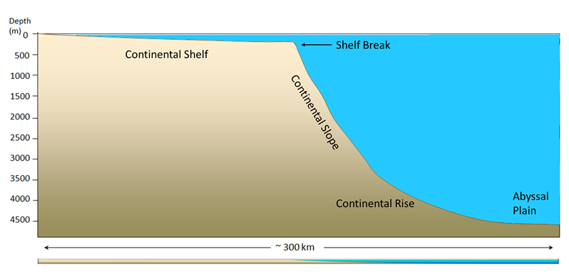
The continental shelf is the shallow, flooded edge of the continent. Geologically the shelf is still part of the continental crust, but it is often overlaid with marine sediments. On average, the shelf extends about 80 km from the coast; some margins have very little shelf, while the Siberian Shelf in the Arctic extends roughly 1500 km. The depth of the shelf generally remains below about 150 m, and the floor of the shelf is fairly flat. The flat topography is the result of changes in sea level; throughout history the shelves have been both submerged and exposed, and as sea level rose and fell, wave action, ice sheets, and other erosional processes smoothed out the shelf surface. Wave action and the movement of sediments over the shelf have continued this smoothing process. Continental shelves only make up about 6% of the ocean’s surface area, but they are biologically one of the richest parts of the ocean; their shallow depth prevents nutrients from sinking out, and their proximity to the coast provides significant nutrient input. The continental shelf ends at the shelf break, which is the point where the angle of the seafloor begins to get steeper. The shelf break averages about 135 m deep.
After the shelf break, the seafloor takes on a steeper angle (about 4o) as it descends to the deep ocean. This steeper portion of the margin is the continental slope, and it extends from the shelf break down to 3000-5000m. In some parts of the ocean, large submarine canyons have been carved into the continental slope; for example, Monterey Canyon in Monterey Bay, California, is a submarine canyon similar in size to the Grand Canyon! These canyons may be carved out by turbidity currents, which are essentially landslides of sediment, rocks, and other debris down the face of the slope.
At the bottom of the slope is the continental rise. This area represents where the continental crust meets the oceanic crust, as the slope begins to level off to become the deep ocean floor. The rise consists of a thick layer of accumulated sediment coming from the continent, so it is difficult to tell where the slope ends and the rise begins.
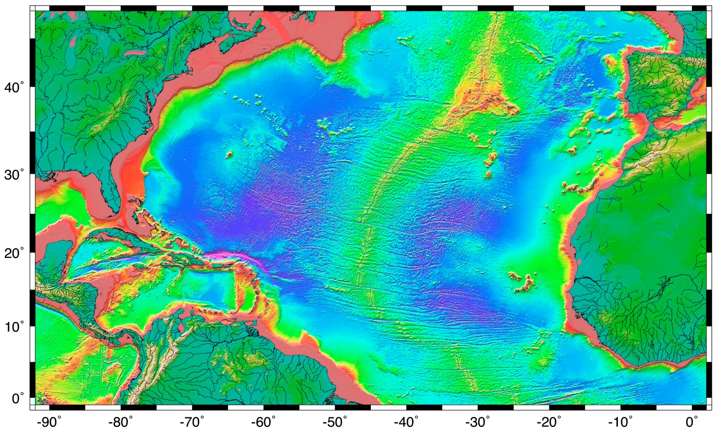
After the rise comes the abyssal plain, or the deep ocean floor, lying between 4500 – 6000 m. The abyssal plain includes most of the ocean floor, and is the flattest region on Earth. It is flat due to millions of years of sediment accumulation on the bottom, which buries many bottom features (Figure 1.2.2).
Passive margins, as described above, have wide shelves, gentle slopes, and a well-developed rise. Since passive margins are not plate boundaries, they experience long periods of relative stability which can lead to the development of these features. Active margins have similar features to passive margins, but the plate boundary affects the properties of the features. Active margins, like the Pacific coast of North America, have narrower shelves, steeper slopes, and little to no rise, particularly in convergent boundaries. Trenches associated with subduction zones act as sediment traps, preventing the accumulation of a continental rise, and keeping sediments off of the abyssal plains.
the region of transition from the land to the deep sea floor, i.e. between continental and oceanic crust (1.2)
the Earth’s crust underlying the continents (as opposed to ocean crust) (3.2)
the Earth’s crust underlying the oceans (as opposed to continental crust) (3.2)
where the boundary between the continent and the ocean is also a tectonic plate boundary (1.2)
a region of the lithosphere that is considered to be moving across the surface of the Earth as a single unit (4.4)
a boundary between a continent and an ocean at which there is no tectonic activity (e.g., the eastern edge of North America) (1.2)
the shallow (typically less than 200 m) and flat sub-marine extension of a continent (1.2)
unconsolidated particles of mineral or rock that settle to the seafloor (12.1)
in the context of primary production, substances required by photosynthetic organisms to undergo growth and reproduction (5.6)
the boundary between the continental shelf and continental slope, where the angle of the seafloor begins to get steeper (1.2)
the steeper part of a continental margin, that slopes down from a continental shelf towards the abyssal plain (1.2)
a current moving down downhill along the bottom, driven by the weight of the sediment within it (1.2)
the area at the bottom of the continental slope, where it transitions to the abyssal sea floor (1.2)
the flat seafloor of the deep ocean, typically beyond the limits of the continental slopes (1.2)
a plate boundary at which the two plates are moving towards each other (4.6)
the sloping region along which a tectonic plate descends into the mantle beneath another plate (4.6)
