
14.1 Types of Ice
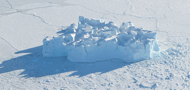
The ice that is seen floating on the ocean’s surface comes from one of two sources. Glacial ice is formed from the accumulation and compression of snow into glaciers, that then break apart and release ice to the ocean. Because glaciers can be several kilometers thick the icebergs that break off of them can be very large; so the tall icebergs at sea always come from glacial ice sheets. Sea ice refers to the ice formed from the freezing of sea water, and rarely exceeds a thickness of several meters (Figure 14.1.1). Sea ice covers about 7% of the ocean at any time, and makes up about 66% of the Earth’s permanent ice cover by area, but only 0.1% of the ice in terms of volume. This is because sea ice is a vast but thin sheet of cover compared to the glacial ice caps that are more localized but may be several kilometers thick.
Sea ice cover around Antarctica fluctuates between about 21 million km2 in winter to around 1.3 million km2 in the summer, with most Antarctic sea ice lasting only a year. Seasonal changes in ice cover are less pronounced in the Arctic, from about 14 million km2 in winter to 6.5 million km2 in summer. About half of the sea ice in the Arctic lasts more than a year to become multi-year ice. This difference arises because Antarctica is surrounded by water, so the ice expands into warmer water and eventually melts. The Arctic Ocean is enclosed by continents, so only about 10% of the ice escapes into the Atlantic between Greenland and Spitzbergen. The rest is trapped and becomes multi-year ice or perennial ice, averaging around 7 years old, and 3-5 m thick, compared to first year ice at 1-2 m thick.
Sea ice formation
Because of the salt content, seawater begins to freeze at about –1.8o C, a lower temperature than for fresh water. Ice formation begins at the surface with the formation of small needle-like ice crystals called frazil, which accumulate and make the water appear slushy and cloudy; this stage is referred to as grease ice (Figure 14.1.2 A). In calmer water these small crystals can freeze together into a thin surface layer called nilas, which can reach a thickness of up to 10 cm (Figure 14.1.2 B).
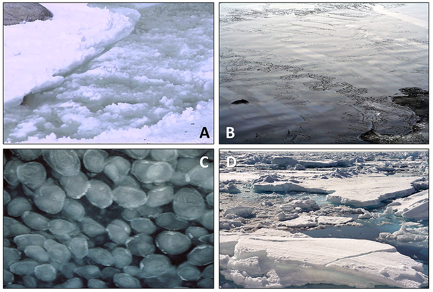
Wave action can break up the nilas into small mats 1-2 m across, which then bump into each other and form rounded shapes with raised edges, called pancake ice (Figure 14.1.2 C). If temperatures remain cold the pancake ice freezes together into solid ice floes, a hard surface covering the ocean (Figure 14.1.2 D). Ice floes then freeze together into ice fields.
Once ice floes form, the water underneath becomes insulated and heat loss to the atmosphere declines, so the water no longer cools and no more ice formation occurs. As a result, young sea ice is usually relatively thin, not more than 3-4 m thick. The ice can get thicker through precipitation; there is not a lot of precipitation at the poles, but due to the low temperatures, whatever does occur tends to accumulate rather than melt. Over time the accumulated ice and snow can add to the overall thickness of the sea ice, but it will still never approach the thickness of glacial ice.
As sea ice crystals form, most of the salt is excluded, so sea ice contains much less salt than seawater, and can be melted for drinking if needed. But about 20% of the salt remains trapped in pockets of water between the ice crystals. As ice forms and salts are excluded into these pockets, the salinity of the remaining water increases and it can become too salty to freeze. These unfrozen pockets of briny water make sea ice a little softer and more slushy than fresh water ice, which is harder and more rigid. Eventually most of this brine leaks out, and the sea ice becomes more solid, but when it is “young ice” it can be more dangerous to walk on than fresh water ice of the same thickness. For example, 7-8 cm of fresh water ice is enough to support the weight of a single person, but you would need at least 15 cm of sea ice to do the same.
The very cold, dense briny water leaks out of the ice and sinks. The brine is “supercooled”; it is cooled below the normal freezing point of seawater, but remains liquid due to the high salt content. When this supercooled brine comes into contact with the surrounding water, it causes the water around it to freeze, creating hollow ice stalactites, or “brinicles” that can be several meters long. Brine continues to flow through the hollow brinicle, and the brinicle grows downwards (see below for an amazing time-lapse video of brinicle formation).
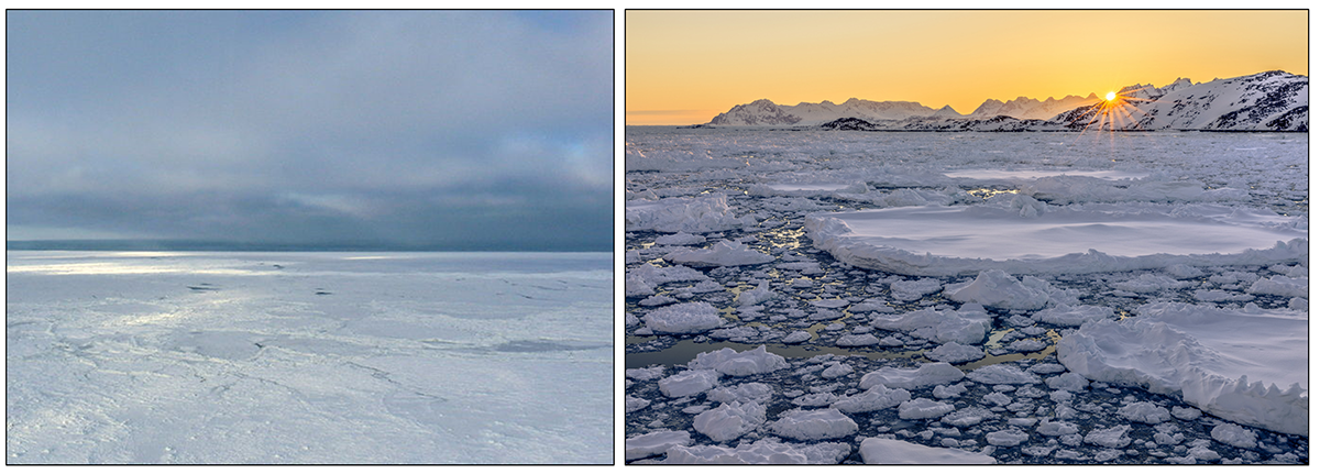
When the large sheets of sea ice are formed, they exist in one of two formations. Fast ice, or land-fast ice, refers to the large, solid ice sheets that are attached to land. The pack ice consists of the smaller, free-floating pieces of sea ice. They may have formed independently, or may have broken off from the fast ice (Figure 14.1.3).
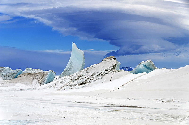
The floating pack ice dampens waves and currents, buffering the sea surface from motion. So changes in the distribution of the pack ice can lead to changes in current patterns, and even alter ecosystem structure. But the pack ice is also subject to the currents flowing underneath, and the ice sheets are constantly on the move, breaking up or being pushed together. When pieces of ice converge, they often buckle and crack, or override one another as in convergent lithospheric plate boundaries (section 4.6). These collisions can create tall, jagged pressure ridges, that may extend for several kilometers, and that create hazards for polar explorers navigating the ice (Figure 14.1.4).
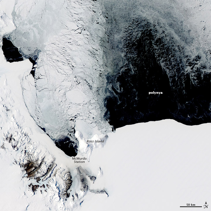
In the polar oceans, ice cover is not uniform. There are a number of areas where there is consistently open water, even though the areas surrounding them are covered by ice. These regions of persistent open water are called polynyas (Figure 14.1.5). Polynyas may be the result of currents or winds moving the ice, or areas of warmer water that prevent ice formation. In Figure 14.1.5, very strong winds blowing offshore from Antarctica’s interior have created a polynya near the edge of the ice sheet.
ice formed from the accumulation and compression of snow into glaciers (14.1)
a large, floating piece of glacial ice (14.2)
ice formed from the freezing of seawater (14.1)
small, needle-like crystals in the first stages of sea ice formation (14.1)
an accumulation of frazil to create a slushy consistency in sea ice formation (14.1)
a thin surface sheet of sea ice (14.1)
small, rounded, thin pieces of sea ice that will freeze together to form an ice floe (14.1)
a relatively large piece of floating sea ice (14.1)
an area covered by ice floes (14.1)
the concentration of dissolved ions in water (5.3)
ice sheets that are attached to land (14.1)
free-floating ice floes (14.1)
a plate boundary at which the two plates are moving towards each other (4.6)
jagged ridges created from colliding and buckling ice floes (14.1)
an area of persistent open water in areas otherwise covered with ice (14.1)
