Want to create or adapt books like this? Learn more about how Pressbooks supports open publishing practices.
4.2 Paleomagnetic Evidence for Plate Tectonics
Modified from "Physical Geology" by Steven Earle*
Although Alfred Wegener would not live to see it, his theory of plate tectonics would gradually gain acceptance within the scientific community as more evidence began to accumulate. Some of the most important evidence came from the study of paleomagnetism, or changes in Earth’s magnetic field over millions of years.
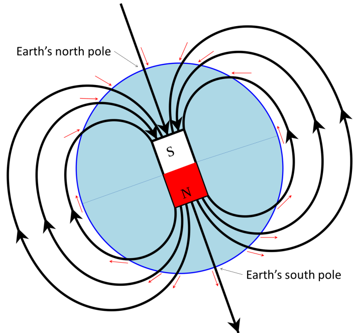
Earth’s magnetic field is defined by the North and South Poles that align generally with the axis of rotation (Figure 4.2.1). The lines of magnetic force flow into Earth in the Northern Hemisphere and out of Earth in the Southern Hemisphere. Because of the shape of the field lines, the magnetic force trends at different angles to the surface in different locations (red arrows of Figure 4.2.1). At the North and South Poles, the force is vertical. Anywhere on the equator the force is horizontal, and everywhere in between, the magnetic force is at some intermediate angle to the surface.
Figure 4.2.1 Depiction of Earth’s magnetic field as a bar magnet coinciding with the core. The south pole of such a magnet points to Earth’s North Pole. The red arrows represent the orientation of the magnetic field at various locations on Earth’s surface (Steven Earle after: http://upload.wikimedia.org/wikipedia/commons/ 1/17/Earths_Magnetic_Field_ Confusion.svg).
In its fluid form, the minerals that make up magma are free to move in any direction and take on any orientation. But as the magma cools and solidifies, movement ceases and the mineral orientation and position become fixed. As the mineral magnetite (Fe3O4) crystallizes from magma, it becomes magnetized with an orientation parallel to that of Earth’s magnetic field at that time, similar to the way a compass needle aligns with the magnetic field to point north. This magnetic record in the rock is called remnant magnetism. Rocks like basalt, which cool from a high temperature and commonly have relatively high levels of magnetite, are particularly susceptible to being magnetized in this way, but even sediments and sedimentary rocks, as long as they have small amounts of magnetite, will take on remnant magnetism because the magnetite grains gradually become reoriented following deposition. By studying both the horizontal and vertical components of the remnant magnetism, one can tell not only the direction to magnetic north at the time of the rock’s formation, but also the latitude where the rock formed relative to magnetic north.
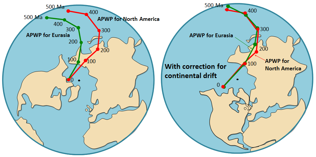
In the early 1950s, a group of geologists from Cambridge University, including Keith Runcorn, Edward Irving and several others, started looking at the remnant magnetism of Phanerozoic British and European volcanic rocks, and collecting paleomagnetic data. They found that rocks of different ages sampled from generally the same area showed quite different apparent magnetic pole positions (green line, Figure 4.2.2). They initially assumed that this meant that Earth’s magnetic field had, over time, departed significantly from its present position, which is close to the rotational pole.
Figure 4.2.2 Polar wandering curves. Curves from Eurasia and North America seem to show that the north magnetic pole was located in two places simultaneously throughout history (left). However, if the continents are rearranged into Pangaea, the two curves overlap, showing that it is the continents than have moved, not the pole (right) (Steven Earle, “Physical Geology”).
The curve defined by the paleomagnetic data was called a polar wandering path because Runcorn and his colleagues initially thought that their data represented actual movement of the magnetic poles (since geophysical models of the time suggested that the magnetic poles did not need to be aligned with the rotational poles). We now know that the magnetic data define movement of continents, and not of the magnetic poles, so we call it an apparent polar wandering path (APWP). Runcorn and colleagues soon extended their work to North America, and this also showed apparent polar wandering, but the results were not consistent with those from Europe (Figure 4.2.2). For example, the 200 Ma pole for North America placed somewhere in China, while the 200 Ma pole for Europe placed in the Pacific Ocean. Since there could only have been one pole position at 200 Ma, this evidence strongly supported the idea that North America and Europe had moved relative to each other since 200 Ma. Subsequent paleomagnetic work showed that South America, Africa, India, and Australia also have unique polar wandering curves. Rearranging the continents based on their positions in Pangaea caused these wandering curves to overlap, showing that the continents had moved over time.
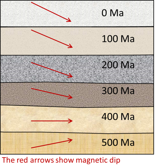
Additional evidence for movement of the continents came from analysis of magnetic dip. Recall from Figure 4.2.1 that the angle of the magnetic field changes as a function of latitude, with the field directed vertically downwards at the north pole, upwards at the south pole, and horizontal at the equator. Every latitude between the equator and the poles will have a corresponding angle between horizontal and vertical (red arrows, Figure 4.2.1). By looking at the dip angle in rocks, we can determine the latitude at which those rocks were formed. Combining that with the age of the rocks, we can trace the movements of the continents over time. For example, at around 500 Ma, what we now call Europe was south of the equator, and so European rocks formed then would have acquired an upward-pointing magnetic field orientation (Figure 4.2.3). Between then and now, Europe gradually moved north, and the rocks forming at various times acquired steeper and steeper downward-pointing magnetic orientations.
Figure 4.2.3 Hypothetical magnetic dip angles from layers of rock. This rock would have been south of the equator 500 Ma, at the equator 400 Ma, and since then has been moving further north (Steven Earle, “Physical Geology”).
This paleomagnetic work of the 1950s was the first new evidence in favor of continental drift, and it led a number of geologists to start thinking that the idea might have some merit.
*”Physical Geology” by Steven Earle used under a CC-BY 4.0 international license. Download this book for free at http://open.bccampus.ca
definition
past variations in the intensity and polarity of the Earth’s magnetic field (4.2)
molten rock typically dominated by silica (3.2)
magnetism of a body of rock that formed at the time the rock formed and is consistent with the magnetic field orientation that existed at that time and place (4.2)
a volcanic rock that makes up much of the oceanic crust (3.2)
unconsolidated particles of mineral or rock that settle to the seafloor (12.1)
the distance north or south of the equator, measured as an angle from the equator (2.1)
the eon on the geological time scale covering time from the beginning of the Cambrian period 541 million years ago to the present, and comprising the Paleozoic, Mesozoic, and Cenozoic eras
a path of varying magnetic pole positions defined by paleomagnetic data (in fact it is now understood that the continents have wandered, not the poles, so a more appropriate terms is “apparent polar wandering path”) (4.2)
(Megaannus) millions of years before the present
the angle of the magnetic field within a rock, relative to the horizontal; may be used to infer the latitude where the rock was first formed (4.2)