
9.1 Surface Gyres
In the previous chapter the major wind patterns on Earth were derived. It is these prevailing winds that blow across the water surface to create the major ocean surface currents. However, only about 2% of the wind energy is actually transferred to the water, so a 50 knot wind only creates a 1 knot current. Furthermore, wind-driven surface currents only affect the top 100-200m of water, meaning surface currents only involve about 10% of the world’s ocean water. In section 9.8 we will examine deep, thermohaline circulation, which impacts around 90% of the ocean water.
Surface currents generally move in the same direction as the winds that created them. However, because of Coriolis deflection, the surface currents are offset approximately 45o relative to the wind direction; 45o to the right in the Northern Hemisphere, and 45o to the left in the Southern Hemisphere. This creates a general circulation pattern where in both hemispheres, surface currents flow east to west between the equator and 30o latitude, west to east between 30o and 60o, and east to west between 60o and the poles (Figure 9.1.1).
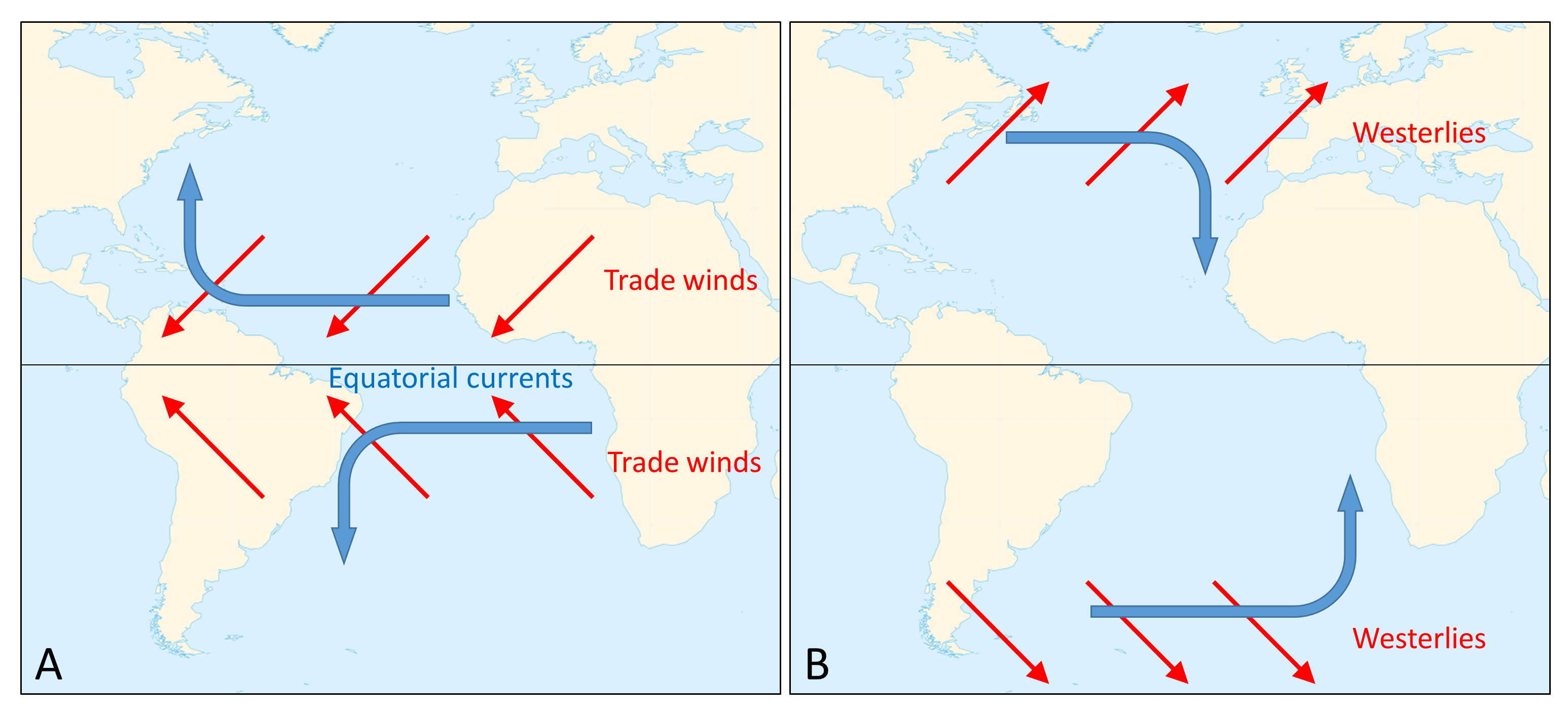
The trade winds create the equatorial currents that flow east to west along the equator; the North Equatorial and South Equatorial currents. If there were no continents, these surface currents would travel all the way around the Earth, parallel to the equator. However, the presence of the continents prevents this unimpeded flow. When these equatorial currents reach the continents, they are diverted and deflected away from the equator by the Coriolis Effect; deflection to the right in the Northern Hemisphere and to the left in the Southern Hemisphere. These currents then become western boundary currents; currents that run along the western side of the ocean basin (i.e. the east coasts of the continents). Since these currents come from the equator, they are warm water currents, bringing warm water to the higher latitudes and distributing heat throughout the ocean.
At the same time, between 30-60o latitude the westerlies move surface water towards the east. The Coriolis Effect and the presence of the continents deflect the currents towards the equator, creating eastern boundary currents (on the eastern side of the ocean basins). These currents come from high latitude areas, so they deliver cold water to the lower latitudes. Together, these currents combine to create large-scale circular patterns of surface circulation called gyres. In the Northern Hemisphere the gyres rotate to the right (clockwise), while in the Southern Hemisphere the gyres rotate to the left (counterclockwise).
There are five major gyres in the oceans; the North Atlantic, South Atlantic, North Pacific, South Pacific, and Indian (Figure 9.1.2). The North Pacific gyre is composed of the North Equatorial Current on its southern boundary, which turns into the Kuroshio Current (a.k.a. the Japan Current) bringing warm water north towards Japan. The Kuroshio flows into the North Pacific Current which moves east towards North America, where it becomes the California Current to complete the gyre. The North Atlantic gyre is formed by the North Equatorial Current flowing into the Gulf Stream along the east coast of the United States. The Gulf Stream merges into the North Atlantic Current to move water towards Europe, which then becomes the Canary Current as it moves south to join the North Equatorial Current.
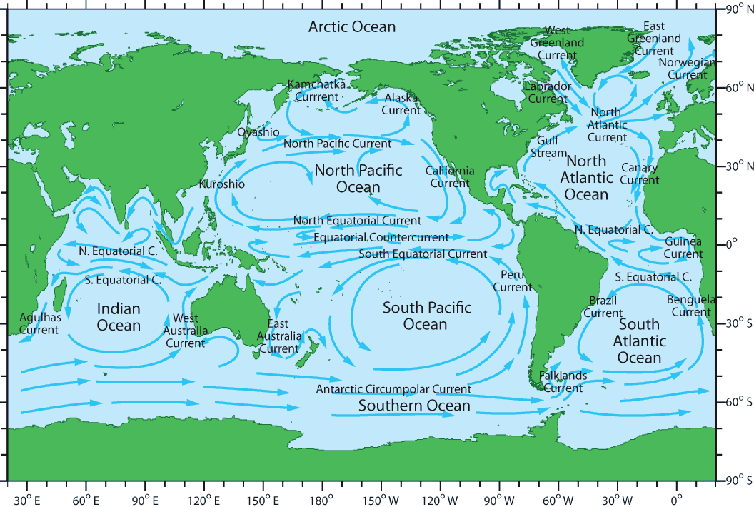
Near Antarctica the circulation is somewhat different. Because there is little in the way of continental land masses between 50-60o south, the surface current created by the westerly winds can make its way completely around the Earth, creating the Antarctic Circumpolar Current (ACC) or West Wind Drift (WWD) that flows from west to east (Figure 9.1.2). The Antarctic Circumpolar Current is the only current that connects all of the major ocean basins, and in terms of the amount of water that it transports, it is the largest surface current on Earth. Above 60o latitude the prevailing winds are the polar easterlies, which create a current flowing from east to west along the edge of the Antarctic continent, the East Wind Drift or the Antarctic Coastal Current.
The Antarctic Circumpolar Current creates the southern boundary for all of the Southern Hemisphere gyres. In the South Pacific gyre the ACC becomes the Peru Current (also known as the Humboldt Current) moving up the west coast of South America, before joining the South Equatorial Current. The South Equatorial Current flows southwards as the East Australia Current, before completing the gyre with the ACC. The South Atlantic gyre is composed of the South Equatorial Current, the Brazil Current, the ACC, and the Benguela Current. Finally, the currents making up the Indian gyre are the ACC, the West Australia Current, the South Equatorial Current, and the Agulhas Current.
Not all of the equatorial water that is moved westward by the trade winds and reaches the continents gets transported to higher latitudes in the gyres, because the Coriolis Effect is weakest along the equator. Instead, some of the water piles up along the western edge of the ocean, and then flows eastward due to gravity, creating narrow Equatorial Countercurrents between the North and South Equatorial Currents (Figure 9.1.2). Some of this water also moves east as equatorial undercurrents that flow at depths between 50-200 m, underneath the Equatorial Currents. These undercurrents are called the Lomonosov Current in the Atlantic, and the Cromwell Current in the Pacific.
one knot (kt) = 1 nautical mile per hour = 1.15 mph = 1.85 kph
deep ocean circulation driven by differences in water density (9.8)
the tendency for the path of moving bodies (e.g., ocean currents) to be deflected on the surface of the Earth, to the right in the Northern Hemisphere and to the left in the Southern Hemisphere (8.2)
the distance north or south of the equator, measured as an angle from the equator (2.1)
prevailing wind bands between the equator and 30 degrees latitude (8.2)
ocean currents whose properties are influenced by the presence of a coastline (9.1)
the dominant wind bands between 30 and 60 degrees latitude in each hemisphere (8.2)
a large circular ocean surface current (9.1)
the dominant wind bands between the poles and 60 degrees latitude (8.2)
