
13.5 Human Interference with Shorelines
The continued erosion and deposition of coastal sediments is a natural process, with features forming and disappearing as sea level and other conditions change. However, we have also come to enjoy and rely on many of these beaches and other coastal features for commerce, recreation, and living space. So from our perspective, we often see the transient nature of the coast as a threat to our activities, and as a result we have developed a number of ways to try and influence the erosion process, usually through hard stabilization, or the building of structures to stop the flow of sand. While some of these efforts have been successful, many others have actually exacerbated the problem, as we will see below.
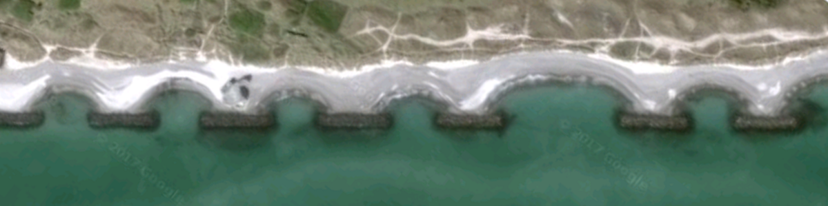
Groins (or groynes) are barriers built perpendicular to the shore (Figure 13.5.1 left). Groins are built to interrupt longshore transport and trap sand upstream of the groin, which they do very well. But downstream of the groin the source of replacement sand is cut off, while sand continues to be removed, so erosion can become even more pronounced on that side of the groin. To prevent that erosion, another groin must be built downstream of the first one, which then creates its own erosion problems, leading to another groin, and so on. Eventually a beach may become covered in a series of groins, called a groin field, all trying to stabilize the natural flow of sand (Figure 13.5.1 right).
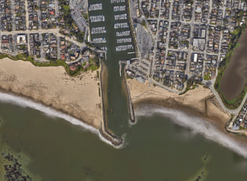
Jetties are like longer groins, often built to protect the mouths of harbors to prevent them from filling with sand. Because they are longer they can trap more sand than groins, and they also can contribute to increased erosion on the downstream side (Figure 13.5.2). If too much sand accumulates upstream of the jetty it can spread past the jetty and into the mouth of the harbor, in which case the jetty may need to be extended.
Breakwaters are walls that are usually built parallel to the shore. Their purpose is not necessarily to interfere with sediment transport, but instead to protect the areas behind them from heavy wave action, so they are often deployed at the mouth of a harbor, or to protect the boats in a mooring field. But breakwaters do have an unintended impact on sediment distribution. Longshore transport continues to move sand along the beach, but once it gets behind the breakwater the lack of wave action interrupts the flow, and the sand settles and accumulates. The beach grows behind a breakwater, until eventually they may become connected (Figure 13.5.3). With the longshore transport interrupted, increased erosion can occur downstream of the breakwater.
Santa Monica Pier
The beach around the Santa Monica Pier in California provides a good example of the effects of breakwaters on a sandy shore. A breakwater was constructed in the early 1930s to protect the pier and the boats that moored near it. Following the construction, the once-straight beach became much wider behind the breakwater as sand accumulated in the absence of strong wave action (below left). Now that the breakwater is no longer in place, the bulge in the shoreline is gone, and the beach is much straighter once again (below right).
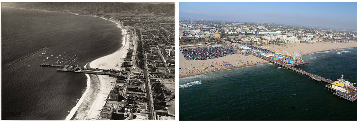 Left; aerial image of Santa Monica Pier and breakwater from 1936 (Courtesy of Santa Monica Public Library Image Archives/ Spence Air Photos). Right; Santa Monica Pier in 2011 (© JCS, CC BY-SA 3.0, via Wikimedia Commons).
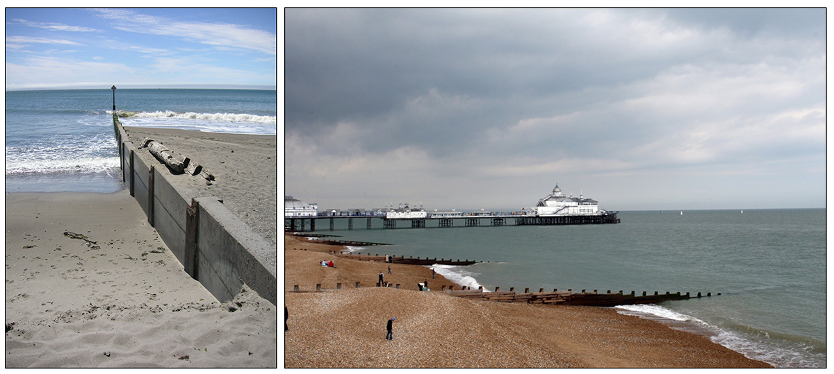
Seawalls are constructed at the top of the surf zone, where the waves crash against the shore. The walls are designed as a barrier between the waves and the shore, to prevent the land from being eroded (Figure 13.5.4). They are often utilized in beachfront property to prevent the ground under a home from being undermined by the waves. However, as with the other forms of hard stabilization we have discussed, seawalls are not without their own environmental consequences. The sudden release of wave energy on a seawall can create turbulence, which undermines the sediment at the base of the wall and causes it to erode. Furthermore, on a softer, natural coastline some of the wave energy is absorbed or dissipated, but with a hard seawall most of the wave energy is reflected, leading to stronger longshore currents and faster erosion. In many places where seawalls have been built the beaches are getting steeper, and erosion rates have increased, with the potential for seawalls to collapse along with whatever they are supporting. Because of this, some coastal communities are phasing out seawall construction to try to return to more natural beach fronts.

unconsolidated particles of mineral or rock that settle to the seafloor (12.1)
the building of physical structures to prevent the erosion of beaches and shorelines (13.5)
a man-made structure extending from the shore built to deflect the energy of waves (13.5)
the movement of sediment along a shoreline resulting from a longshore current and also from the swash and backwash on a beach face. Also known as littoral drift (13.2)
a series of groins along a beach (13.5)
a long structure built to protect a harbor from filling with sand due to longshore transport (13.5)
a structure built offshore in order to deflect the energy of waves (13.5)
a wall built against a sea cliff or dune to prevent erosion from wave action (13.5)
